


Article: Earth 2026: A Planet Under Pressure
Earth 2026: A Planet Under Pressure
Earth 2026: A Planet Under Pressure
Earthquakes, Volcanoes, Floods & Climate — The Complete Scientific & Travel Safety Guide — August 11, 2026

📋 TABLE OF CONTENTS

Earthquakes shook the Pacific. Volcanoes pulsed around the Ring of Fire. Floods overwhelmed cities and river plains. Europe and the United States baked under extraordinary heat. Wildfires transformed landscapes, while the oceans stored record warmth. None of these events has a single cause. But together they reveal something more consequential: the growing collision between Earth’s natural systems and a civilisation built across their most hazardous edges.
At First There Is Only Water
At first there is only water.
It is everywhere in Assam: spilling across fields, swallowing roads, surrounding houses, carrying branches and livestock debris downstream. The Brahmaputra has risen beyond its banks, as it has done for centuries, but the scale of the human disruption is modern. Villages are cut off. Roads disappear beneath brown water. Families move into relief camps carrying what they could save.
By August 10, the flooding in India’s northeastern state had killed 100 people and displaced more than 700,000. Nearly 300,000 people had taken shelter in government-run camps as several rivers remained above danger levels.
The scene could be mistaken for the defining image of 2026. But halfway around the world, the ground tells another story.
On March 23, a magnitude-7.5 earthquake struck west of Neiafu, Tonga. It happened roughly 234 kilometres below the surface, inside the Pacific Plate as that slab descended beneath the Australia Plate. It was not a shallow rupture at the plate boundary. It was an earthquake within the sinking slab itself.
And in Hawaiʻi, Kīlauea continued to glow. Inside the summit caldera, magma rose and fountains of lava appeared intermittently above Halemaʻumaʻu. By July, the eruption remained active, with episodic fountaining and the alert level generally at Advisory.
Then came the heat. Across Europe, persistent warmth and dryness transformed the landscape. Western Europe experienced its hottest June-July period on record. In July, global sea-surface temperatures also reached a record for that month, while exceptional marine heat affected the Atlantic and western Mediterranean.
Across the Gulf of Guinea, more than 140 millimetres of rain fell in less than 24 hours in some places during the June flooding. Scientists later estimated that the intensity of three-day rainfall events in the affected area had increased by about 23 percent since observations began and that an event of this magnitude was now roughly five times as likely as it would have been in the pre-industrial climate.
Earthquake. Volcano. Flood. Heatwave. Wildfire. Put them on the same page and the conclusion seems obvious: Earth is becoming more violent. But that conclusion is wrong. The more revealing story is that several different Earth systems are producing extremes at the same time — and humanity has built an enormous, interconnected civilisation directly across the boundaries between them.
Part I: The Planet Beneath Our Feet
The First Mistake: Assuming Every Disaster Has the Same Cause
Earth has always been restless. The continents move. Ocean floors spread. Mountains rise and erode. Faults accumulate stress. Magma rises. Rivers migrate. Glaciers advance and retreat. Storms reorganise the atmosphere. The physical processes are ancient. What has changed is the scale at which humans observe them — and the scale at which human societies are exposed to them.
The United States Geological Survey has repeatedly cautioned against interpreting short-term fluctuations in earthquake counts as evidence that Earth is becoming seismically more active. The apparent clustering of large earthquakes can result from normal statistical variation, aftershock sequences and improvements in detection. Modern technology also changes our perception. A powerful earthquake in the South Pacific can become a global headline within minutes. The news cycle creates patterns. Geology does not follow them.
The Tonga Earthquake
The March earthquake near Tonga is a perfect example of why magnitude alone tells an incomplete story. A magnitude-7.5 earthquake sounds enormous — and it is. But the event occurred at approximately 234 kilometres depth, placing it in the category of intermediate-depth earthquakes: seismic events occurring within a descending tectonic slab rather than at the shallow plate boundary itself.
The Tonga region is one of the world’s great natural laboratories for understanding subduction. The Pacific Plate is being driven beneath the Australia Plate. As the oceanic slab descends into the mantle, it bends, fractures and undergoes enormous changes in pressure and temperature. Because the earthquake was deep, its shaking could travel over enormous distances without necessarily producing the level of surface destruction associated with a shallow earthquake of similar magnitude. That illustrates a crucial principle: magnitude is not destiny. Depth, distance, local geology, building quality and population exposure all determine consequences.

The Philippines: Where Tectonics Meets Human Vulnerability
The Philippines experienced a much more direct demonstration of the relationship between earthquake geology and human vulnerability in June. A magnitude-7.8 earthquake struck offshore near Mindanao on 8 June, killing at least 35 people and injuring more than 200. The earthquake triggered a landslide and generated a tsunami of around one metre in nearby areas.
The Philippines sits within one of Earth’s most tectonically complex environments, surrounded by active plate boundaries and trenches. It is part of the broader Pacific Ring of Fire, where oceanic plates are continuously being subducted. The result is a landscape where earthquakes, volcanoes and tsunamis are not unusual intrusions — they are fundamental expressions of the region’s tectonic architecture.

Volcanoes: A Planet Breathing Through Its Crust
The Smithsonian Global Volcanism Program recorded 47 volcanoes with confirmed eruptive activity during part of 2026. Earth has always been volcanically active. The USGS estimates that roughly 1,350 potentially active volcanoes exist worldwide, excluding the enormous number of submarine volcanoes. About 500 have erupted during historical time.
What 2026 demonstrates is not a sudden planetary volcanic awakening but the extraordinary diversity of volcanic behaviour. Kīlauea in Hawaiʻi is a shield volcano dominated by basaltic magma. Its rhythm — magma enters, pressure builds, the summit inflates, lava fountains, the summit deflates, the eruption pauses, then the system recharges — is almost as though the volcano is inhaling and exhaling.
Elsewhere, the Smithsonian’s 2026 records include activity at Lewotobi in Indonesia, Akan in Japan, Mayon in the Philippines, Whakaari/White Island in New Zealand, Lascar in Chile and Piton de la Fournaise on Réunion. These volcanoes are not manifestations of a single global pulse. They are individual systems responding to their own magma reservoirs, fractures, pressure conditions and tectonic environments.

Part II: The Atmosphere Above Us
Water: The Other Half of 2026
A warmer atmosphere can hold more water vapour. When conditions allow that moisture to condense and fall, rainfall can become extremely intense. The relationship is not simply “warmer equals wetter everywhere” — climate dynamics are much more complicated. But the physical foundation is straightforward: a warmer atmosphere has greater capacity to contain moisture, while warmer oceans can supply additional evaporation.
Assam’s vulnerability is not accidental. The Brahmaputra is one of the world’s great sediment-carrying rivers, flowing through an enormous sedimentary basin bordered by the Himalayas. Every year, enormous quantities of water and sediment move through the region. The landscape is dynamic by nature. In geological terms, flooding is part of how the landscape is built. In human terms, however, the same process can be devastating when settlements, roads, farms and bridges occupy the floodplain.
The Gulf of Guinea: The New Geography of Flood Risk
Between 20 and 22 June, exceptionally heavy rainfall affected coastal Côte d’Ivoire, Ghana, Togo and Nigeria. The World Weather Attribution analysis found that the intensity of three-day rainfall events in the region has increased by approximately 23% since observations began and estimated that an event of this magnitude is now about five times more likely than in the pre-industrial climate.
The key phrase is not “climate change caused the flood.” It is that climate change altered the probability and intensity of the rainfall that produced the flood. Urbanisation is transforming the physical surface of the region. Vegetation is removed. Soil is covered by roads and buildings. Natural drainage channels are altered. Water follows gravity. If the drainage system cannot move the water away quickly enough, the city itself becomes part of the flood mechanism.

Europe’s Heat: The Atmosphere Becomes Geological
Western Europe experienced its warmest June-July period on record in 2026, according to the Copernicus Climate Change Service. In early August, central and eastern Europe experienced another intense heat episode. Slovakia reached 42.2°C, Hungary broke a long-standing temperature record, and the Mediterranean reached sea-surface temperatures around 33°C.
The most significant geological effect of prolonged heat is what it does to the hydrological system. Soils dry. Vegetation loses moisture. Groundwater recharge declines. Rivers fall. Reservoirs shrink. Wildfire risk rises. Then, when intense rain finally arrives, the dry landscape may respond differently — vegetation burned away, compacted surfaces generating rapid runoff, slopes becoming unstable.

The United States and the Heat Dome Problem
The United States experienced an extraordinary July in 2026. Reporting based on NOAA data described July as the hottest month on record for the contiguous United States, with an average temperature around 1.8°C above the twentieth-century July average. Multiple heat-dome episodes affected broad parts of the country, while drought and wildfire conditions intensified in several regions.
A warmer baseline means an extreme heat event begins from a higher starting point. Imagine rolling a die where the entire distribution has shifted upward. The most extreme outcomes become easier to reach. That is essentially what global warming does to temperature extremes.
Part III: Where Geology and Climate Collide
Landslides: The Intersection
If one wants a single natural hazard that best represents the intersection between geological processes and climate change, it may be the landslide. A landslide requires a slope — and the slope is geological. Its rocks, faults, fractures, bedding planes and weathering history determine how stable it is. But water can change everything. When rain infiltrates soil and fractured rock, it increases pore-water pressure. That can reduce the effective friction holding material together. Saturated soils become heavier. Weak layers become lubricated. Eventually gravity wins.
Research on northeastern India’s Mizoram region found that projected increases in extreme precipitation could increase the fraction of landslides occurring in a near-synchronous, low-warning regime under high-emissions scenarios. The danger is not simply more landslides — it is potentially less warning time.
The Ocean: The Silent Amplifier
The World Meteorological Organization confirmed that the 11 years from 2015 through 2025 were the hottest 11 years in the instrumental record and that Earth’s energy imbalance was at its highest in the 65-year record. The ocean has absorbed an extraordinary amount of excess heat. In July 2026, global sea-surface temperatures reached extraordinary levels, while severe marine heatwaves affected portions of the Atlantic, Pacific and western Mediterranean.
Warm oceans influence atmospheric moisture, tropical cyclone behaviour, marine ecosystems and regional weather patterns. The ocean is therefore not just a victim of climate change — it is part of the machinery through which climate extremes are transmitted.

Part IV: The Risk Landscape
The Most Dangerous Regions of 2026
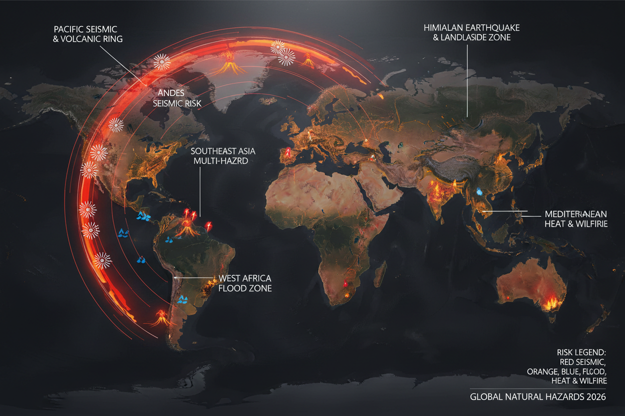
A meaningful 2026 risk map cannot simply colour the entire planet red. Different hazards have different geographies. The Pacific Ring of Fire remains the world’s dominant zone of earthquake and volcanic risk. The Himalayan arc remains a major earthquake and landslide zone. Southeast Asia is particularly exposed because tectonic hazards, tropical rainfall, monsoon flooding, volcanic activity and dense coastal populations overlap. The Gulf of Guinea and West African coast are increasingly important flood-risk zones. Southern and central Europe face escalating compound heat, drought, wildfire and water-security risks.
The most dangerous regions are not necessarily those with the most extreme individual hazard. They are the places where multiple hazards overlap with dense populations and fragile infrastructure.
The Future: Compound Disasters
The future will not necessarily be defined by a single hazard becoming dramatically worse everywhere. It may instead be defined by hazard combinations: a heatwave followed by drought, a drought followed by wildfire, a wildfire followed by extreme rainfall, extreme rainfall followed by landslides, a tropical cyclone arriving after weeks of saturated soil.
These combinations are dangerous because modern society is interconnected. A flooded railway can interrupt food distribution. A drought can reduce electricity generation. Low river levels can disrupt shipping. A wildfire can close airports. A heatwave can reduce the efficiency of power plants. The disaster is no longer confined to the place where it begins.

Frequently Asked Questions
Q: Is 2026 an unusually active earthquake year?
A: Not dramatically so by historical standards. The USGS catalog shows approximately 79+ M6+ earthquakes through late July and around 10 M7+ events by August 10 — within the range of normal annual variability. What makes 2026 feel different is the concentration of deadly events in Venezuela (6,300+ deaths) and Colombia (100+ deaths) in a compressed timeframe with immediate global media coverage.
Q: Are the Venezuela and Colombia earthquakes connected?
A: No scientific evidence supports this. While both countries sit in the same broad tectonically active region, earthquakes this far apart do not generally transfer enough stress to trigger one another directly. Scientists emphasise that earthquake clusters reflect normal statistical variability.
Q: Is it safe to travel to Colombia right now?
A: Avoid travel to the Chocó region and earthquake-affected areas as of August 11, 2026. Rescue operations are still active, infrastructure is damaged, and aftershocks are expected. Check your government’s travel advisory before any travel to Colombia.
Q: What caused the floods in Assam in 2026?
A: The Brahmaputra river system floods naturally every monsoon season — it is part of the geological character of the region. Climate change may be altering the timing and intensity of rainfall, but the Brahmaputra has always flooded. The 2026 disaster reflects both natural cycles and human exposure on floodplains.
Q: Is climate change causing more earthquakes and volcanic eruptions?
A: No. Earthquakes and most volcanic eruptions are driven by Earth’s internal geological processes — plate tectonics, magma generation and fault stress — which are unrelated to surface temperature changes. Climate change intensifies heat extremes, alters rainfall patterns and contributes to flood and wildfire risks, but it does not cause earthquakes or volcanic eruptions.
Q: What is the Ring of Fire?
A: The Ring of Fire is a roughly horseshoe-shaped zone around the Pacific Ocean where approximately 90% of the world’s earthquakes occur and where most of the world’s active volcanoes are located. It follows the boundaries of several tectonic plates — including the Pacific, Philippine, Juan de Fuca, Cocos and Nazca plates — where subduction, collision and transform faulting generate intense seismic and volcanic activity.
Q: How many earthquakes happened in 2026?
A: Through late July 2026, the USGS M6+ catalog recorded at least 79 earthquakes of magnitude 6.0 or greater, including approximately 10 events of magnitude 7.0 or greater. The largest was the M7.8 Philippines earthquake on June 7. The most deadly were the Venezuela doublet (M7.2 + M7.5, June 24) and the Colombia M7.4 (August 10).
Q: How can I monitor earthquake and volcanic activity in real time?
A: Bookmark the USGS Earthquake Hazards Program (earthquake.usgs.gov) for real-time global earthquake data, and the Smithsonian Global Volcanism Program (volcano.si.edu) for volcanic activity. For your destination country, check the national meteorological or geological agency for local alerts.
Q: What should I do if I am in an earthquake?
A: Drop, Cover, Hold On. Get under a sturdy table or desk, cover your head and neck, and hold on until shaking stops. Do not run outside during shaking — falling glass and debris are the primary killers in urban earthquakes. After shaking stops, be aware of aftershocks and do not re-enter damaged buildings.
Q: Why are 2026 natural disasters getting so much media attention?
A: Several factors combine: the Venezuela and Colombia earthquakes were exceptionally deadly; social media enables near-instant global sharing of disaster footage; and the simultaneous occurrence of multiple high-profile events — earthquakes, floods, heatwaves — creates a perception of unprecedented activity. Scientists caution that the underlying geological activity is within historical norms.
Conclusion: A Final View from Space
Imagine looking down at Earth from orbit in August 2026. The Philippines and Indonesia sit along the glowing arc of the Ring of Fire. Japan is marked by volcanoes and earthquake zones. The Andes form a long tectonic scar along South America. The Himalayas rise like a geological wall across Asia. Across Europe, brown drought scars and red wildfire zones spread through landscapes under exceptional heat. Blue flood zones appear along rivers and deltas. Over the ocean, vast areas glow with anomalously warm colours.
None of these systems exists independently. That is the real story of Earth in 2026. Not that the planet has suddenly become angry. Not that every earthquake, volcano, flood or heatwave has a common cause. But that the Earth’s internal geological engine and its external climate engine are operating simultaneously — and human civilisation sits directly at their intersection.
It is not the year when Earth suddenly became more violent. It is the year when the connections between Earth’s systems became harder to ignore.
Because the central question of the coming decades will not simply be: “What will Earth do next?”
It will be: “Where will we be when it does?”

Sources & References
Earthquake Data
• USGS Earthquake Hazards Program — World M6+ in 2026 — earthquake.usgs.gov
• Reuters — “More than 100 killed after strongest quake this century hits western Colombia”
• Insider Paper — “Ten magnitude 7+ earthquakes struck worldwide in 2026”
• Chosunbiz — “Experts say global quake clusters reflect normal variability, not awakening”
• AP News — Philippines M7.8 earthquake, June 7, 2026
• Al Jazeera — Colombia casualty figures, August 10–11, 2026
• The Times of India — Venezuela death toll reporting
• Earthquake List — Colima Earthquake Report, Mexico
Volcanic Activity
• Smithsonian Global Volcanism Program — volcano.si.edu
• USGS Volcano Hazards Program — volcanoes.usgs.gov — Kīlauea monitoring, July 2026
Floods, Heat & Climate
• AP News — Assam flooding, August 10, 2026
• World Weather Attribution — Gulf of Guinea rainfall; South Asian heat; European heat
• Copernicus Climate Change Service — Europe hottest June-July on record, 2026
• Reuters — European heatwave and wildfire reporting
• The Guardian — Slovakia 42.2°C; Hungary record; Mediterranean 33°C; US July record
• NOAA (via The Guardian) — US hottest July on record
• AP News — Tropical Storm Dolphin, China flooding
• World Meteorological Organization — State of Global Climate 2025 report
• Financial Times — Global sea-surface temperature records, July 2026
Scientific Research
• arXiv — Mizoram landslide research: extreme precipitation and warning time
Data note: Earthquake and volcanic activity described in this article reflects geological processes unrelated to climate change. Attribution of heat and rainfall extremes to climate change is event-specific, based on published World Weather Attribution analyses and Copernicus Climate Change Service data. Climate change is not claimed as a cause of tectonic or volcanic activity. Colombia and Venezuela casualty figures are preliminary and subject to revision. Reporting cut-off: August 11, 2026.